Enedis
Optimizing grid lifecycle management with visual data and artificial intelligence
Enedis operates 330,000 km of overhead lines, many of which are 30-40 years old. Rather than replacing them all—an option with significant ecological impact—Enedis seeks to responsibly extend their lifespan by replacing only the necessary components. To achieve this, Enedis partnered with the Æther AI platform in 2020, using AI and visual data to enhance its digital transformation and efficiently monitor its medium voltage overhead network.
We aim to extend the lifespan of our equipment responsibly by replacing only the components that truly need it. This can be achieved by utilizing visual data and artificial intelligence, combined with Enedis' expertise and collaboration with partners like Alteia. This eco-friendly smart-grid approach allows for the modernization of 7,500 kilometers of power lines each year, with only 25% of the equipment needing replacement.
Marianne LaigneauPrésidente du Directoire
Instance segmentation at image level
The process involves identifying and isolating individual objects within an image to simplify its complexity and make the analysis more efficient. This approach achieves a detection precision ranging from 85% to 97% and a recall rate between 85% and 96% across 13 different classes of objects. These high detection and recall scores indicate that the system is highly effective at accurately recognizing and distinguishing various objects while minimizing false negatives, making it a robust solution for complex image analysis tasks.
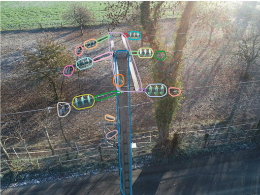
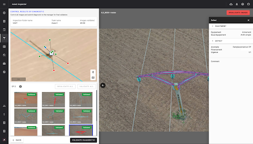
Image classification at equipment level
The model evaluates each piece of equipment by classifying it into one of two categories— "ok" or "ko" (defective)— based on the specific set of anomaly classes defined for that type of equipment. By identifying whether the equipment is functioning correctly or has defects, the model helps in quickly assessing its condition. This binary classification approach ensures targeted maintenance and efficient decision-making, as it allows for the prompt identification of equipment that requires further inspection or repair based on predefined anomaly criteria.
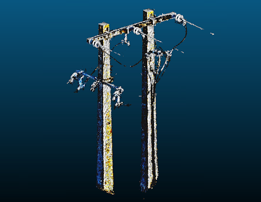
3D reconstruction leveraging NERF technology
NeRF leverages deep learning to create a continuous 3D representation of a scene from a collection of 2D images, producing an implicit model rather than a conventional 3D model. This 3D representation enables each image to be accurately positioned within its spatial context, enhancing the efficiency and depth of the analysis workflow.